This is the third in a series of articles that seeks to outline the steps required to subdivide land and illuminate some of the practical issues, from a surveyor’s perspective.
A reminder that the initial steps might look like this:
Step 1 is a focus on investigating whether a particular site can feasibly be subdivided. This is typically a desktop assessment that considers the site itself, the relevant District Plan rules, the infrastructure and services (or lack of) to the site and other relevant information.
The initial investigation under Step 1 seeks to garner some confidence that the site can be subdivided under the relevant rules but also identify the areas of risk for the proposed subdivision (typically infrastructure requirements, ground conditions, topography, natural hazards, other site constraints).
Step 2 seeks to collect more specific, detailed information about the site itself. This requires a physical survey of the site to collect information about the topography and site features. In this period, it will also be common to engage a geotechnical engineer and stormwater engineer so they can begin site testing and produce reports that will help to inform how the subdivision or land development will proceed with respect to foundations, pavement formation, stormwater management (etc as relevant).
Step 3: Design
Once the topographic and site surveys have been done the subdivision can be designed in more detail, and a subdivision scheme plan is produced. This will typically be further development of a concept plan that may have been prepared under Step 1.
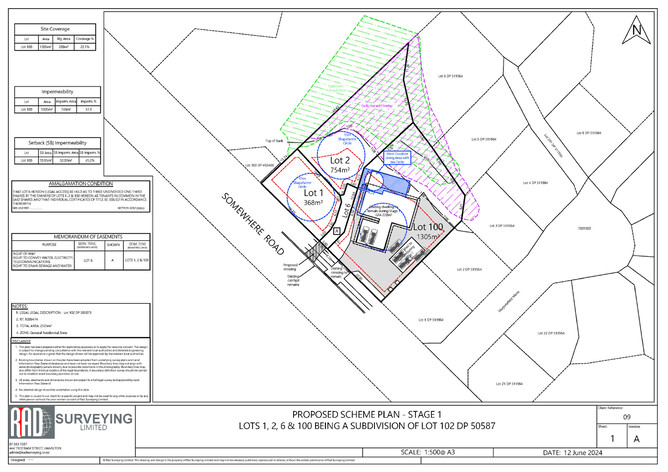
The subdivision scheme plan is a critical output. If the subdivision goes ahead, it becomes the keystone of the subdivision consent. Once a subdivision consent issues, that gives effect to the subdivision shown on the scheme plan, the subdivision cannot be changed without formal application to Council (which can be just as comprehensive as the initial application). Therefore, it is important to spend time carefully preparing and reviewing the subdivision scheme plan.
Example of a scheme plan design
The subdivision scheme plan identifies things like lot sizes and positions, new boundaries, vehicle access (which could be a shared lot), new roads, easements that might be required, how existing easements affect the proposed lots. The scheme plan can also incorporate existing infrastructure that is known about and is to be kept in place (for example existing vehicle access).
The subdivision design needs to account for all the relevant rules in the District Plan and be designed to suit the topography of the site. In Hamilton city, as well as lot sizes, lot dimensions and vehicle access requirements, the subdivision design must account for street trees, power and phone infrastructure (i.e. avoiding each of these), adjacent vehicle crossings, road status (e.g. local, collector road etc). The existing infrastructure may also inform the design. There may be stormwater or wastewater pipes running through the site, or infrastructure depths may create limitations (e.g. gravity wastewater may not be viable unless carefully designed for). Topography is highly relevant; gully banks are subject to building setback rules that must be accounted for.
At this stage the surveyor will begin to consider what earthworks will be required for the subdivision, and what ground levels need to be achieved.
Often, subdivision must be done in tandem with built development on the site, for example residential units are also to be built (these could be duplex units, or apartments or standalone dwellings). A building designer must be involved to develop concept plans for the units. The designer’s plans and the subdivision scheme plan must be co-ordinated so that they are entirely aligned and consistent with each other.
The subdivision scheme plan prepared at this early stage is still a work in progress but it now shapes and informs the next steps in the subdivision which will be detailed further in the next parts of this blog series.

